Sun Koshi Landslide: Indian Remote Sensing Satellite Data - Visual Analysis
Sun Koshi Landslide: Indian Remote Sensing Satellite Data - Visual Analysis
Indra Sharan KCSept 29, 2014.
Kathmandu
This blog is based on data and information made available at
National Remote Sensing Center Website: http://nrsc.gov.in/ Accessed on Sept 17, and 29, 2014). Therefore NRSC is gratefully acknowledged. All the images are provided with their original source links. These images are copy righted to NRSC/ISRO.
National Remote Sensing Center (NRSC) of Indian Space Research Organization (ISRO), Government of India published Satellite Images of recent Landslide on Sun Koshi River in Nepal.
The landslide had taken place on August 2, 2014. The landslide killed 156 people and destroyed 33 houses; a 2.5 KW hydropower plant in Sunkoshi Bazar; intake structure of 10 KW Sunkoshi hydro in Lamosangu; transmission lines and towers and about 1.5 KM of road in Ramche and Jure. There was 67 MW of power less in the grid, due to this landslide which added extra 4 hours of load shedding in the regular load shedding of daily 10 hours. Significant amount of agricultural land and forest was impacted by the mega landslide.
Nepal Army had been using light explosives, heavy equipment and muscle power to clear open channel to release water from the 2.36 km long, 200 m wide lake with a surface area of 44 Ha formed from the 5.5 million cubic meter debris deposit on Sun Koshi's bend that is exactly at the intersection of 4 Village Development Committees (VDCs), namely, Ramche, Mangkha, Tekanpur and Duskhun, of Sindhupalchok district. So, the landslide affected people and area of those 4 VDCs.
The Indian Remote Sensing (IRS) Satellite images provide a great deal of valuable visual information. First, there was no areal or space view to inform scientists and concerned people on the scale and magnitude of the landslide and its impact area. Second, quantitative data on landslide and lake parameters were all speculative. The images available at nrsc.gov.in answer these two questions very precisely.
There are two types of IRS Images provided by the NRSC on Sun Koshi Landslide.
LISS IV - multi-spectral images ( Spatial resolution: 5.8 meter at nadir)
A LISS-IV sensor operates in multi-spectral and Mono mode. This sensor provides data with a spatial resolution of 5.8m (at nadir) in both the modes.
In the Mono mode, the sensor provides data of a single band in the visible region, with a swath of 70 Km (at nadir) and across track steerability of + 26
degrees. In the multi-spectral mode, the sensor provides data of three bands with a swath of 23Km.
When the lake was fully formed:
The image was taken by RESOURCESAT on 5th August. Here is the link to the images. The measurements data on the landslide and lake are given on the image itself. The Indian National remote Sensing Center LISS IV images are here.
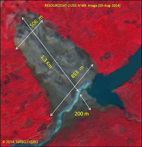

The landslide width at the top and bottom portions measured 506 and 853 meters. The width of the dam (across the river) measures to be 200 meter.
Similarly, the length of the lake (straight from the dam to to Sunkoshi bazar at the confluence of Sun Koshi and Bhote Koshi rivers) is shown to be 2.36 KM. From the measurement on image, the area of the lake is 44 Ha.
The measurement is done on-screen using geo-referenced satellite image, and the value can change slightly from person to person. Perhaps these measured values are close to themselves 95% of the time.
Post- dam opening (post Sept 7) image:
The landslide lake suddenly eroded the channel created by the Army and 60 percent of water released in early hours of September 7, 2014. Not serious damage was noticed, although the villages just downstream were evacuated by the people themselves for fear of being washed away by the landslide lake outburst flood. The image clearly shows the decrease in water level. The upper portion of lake (the area near Sun Koshi bazaar, the confluence of Sun Koshi and Bhote Koshi)) is now out of water. Similarly the area near the dam where a small stream by name Dabi Khola meets Sun Koshi, is also out of water impoundment. Village called Tekan, at this confluence, which is about a kilometer away from the landslide, was destroyed by the landslide and formation of the lake. This image of September 17, clearly shows this change.

CartoSat Panchromatic Images: (Spatial resolution: 2.5 meter at nadir)
National Remote Sensing Center, Hyderabad also acquired CartoSat-2 data over the landslide on August 23, 2014, when the lake was still intact. Cartosat data are high resolution (2.5 meter), and the measurements on this data yields better results. This image provides a great view of the landslide and the extent of the lake. Satellite CartoSat carries two PAN sensors with 2.5m resolution and fore-aft stereo capability. The payload is designed to cater to applications in cartography, and terrain modeling. However, the NRSC has only provided measurement data using LISS IV MX data, which is 5.8 meter in resolution.
This image although has some clouds at the upper part of the landslide, has best captured the landslide and the lake in great details.


Quantitative measurements of Sun Koshi Landslide, Dam and Lake as provided by NRSC
The data from the satellite imagery provides the following information.
Length of Landslide:
The length of the longest portion of landslide on plan view is 1.5 km. NRSC using LISS IV image labels it 1.3 KM.
Width of the landslide:
The width at top is about 500 meter. The width at the bottom part is 900 meter. The landslide tapers from 900 meter at the bottom to 428 meter at the bottle neck portion above at 1.14 KM from the river bed. The average width of the landslide is 600 meter. The NRSC's LISS IV data is labelled as: 506 and 853 meters.
Landslide Dam:
Height (most of the reports) : 55 meter
Dam length: 300 meter
Length of toe of the dam: 700 meter
Gradient of the toe: 1:6 (calculated from photographs taken in the field).
Width of dam: 150 meter.
Landslide Lake:
Straight line distance as given by LISS IV data: 2.36 KM.
Area as LISS IV, reported by NRSC: 44 Ha.
Further analysis will follow in next blog.
http://thehimalayanuniverse.blogspot.com
Reference:
CARTOSAT 1, Data User's Handbook, National Remote Sensing Center, Indian Space Research Organization, available here.
RESOURCESAT-2, Data User's Handbook, National Remote Sensing Center, Indian Space Research Organization, available here.
National Remote Sensing Center Website: http://nrsc.gov.in/ Accessed on Sept 17, and 29, 2014).

Comments